Hello from the Maple crew!!
We are slowly making progress towards Galapagos. We have managed to fly the spinnaker a few times over the last few days, but the wind has come further forward and we are now gently sailing under calm seas and winds with the full main and genoa. This afternoon the winds died out entirely so we figured it was the perfect opportunity for our last swim in the Northern Hemisphere for awhile. The water temperature was actually warmer than it was at Las Perlas.
We are still waiting for the orcas to show up, which were promised to me on this leg of the trip. Clearly can't rely on their scheduled show. In the meantime, we had some dolphins pay us a brief visit at the stern. We also regularly have a bird or two circling around Maple day and night. It is a little eerie how the birds glow green from the nav lights at night, but it is something to keep us company under perfectly clear, starry night skies. Unfortunately the last two mornings we have had to clear off a number of squid that clearly were escaping danger only to end up glued to the front deck of Maple. Not exactly the wildlife encounter I was hoping for.
Today we are making preparations for our offerings to Poseidon and our initiation ceremony to the Southern Hemisphere. Our timing for crossing the equator might not be timed well but we will force the girls from their beds to celebrate the occasion if necessary. Pictures from the momentous event will follow when in the land of internet again.
At 2019-03-31 23:45 (utc) our position was 00°40.94'N 087°29.86'W

Sunday, 31 March 2019

Wednesday, 27 March 2019
End of day 1
Hello from Maple and her crew of happy sailors!
An eventful day today. Good sailing with the wind coming from North we set ourselves up wing on wing with the wind at 150 degress on the starboard side. Wind speeds started out around 20 knots true, and built through the day. By about 2:00 we were seeing 35 knots gusting to just shy of 40. Maple was clocking in speeds over 10+ knots for a sustained period. Then the seas began to get steep and we started surfing down waves. We decided to play it safe and avoid broaches and accidental gybes (after the first one) and set ourselves up with the wind at 120 degrees starboard. This is pointing us a bit north of the Galapagos, but winds and seas are supposed to calm this evening into tomorrow so we will point further south then. The seas are strangely steep even though wind and current are running together but Maple is handling it all well. We have had water come into the cockpit a couple of times but we are none the worse for wear. (Oh sure, says the guy who didn't get soaked!!! - J)
The wind is cold, coming from the North and we find ourselves bundled in jackets and warm socks for the night watch,looking forward to warmer temps and water south of the equator.
As a final note, we did catch a fish today, a small tuna that will do nicely for a couple of meals...it's been a long time since a good eating fish came aboard and I was pretty happy, even if I did have to make some emergency repairs to my fishing rod.
That's all from Maple, hope all of you are well.
Please remember not to include this message in any replies you send.
-----
At 2019-03-27 10:24 PM (utc) our position was 05°37.70'N 080°55.24'W
Tuesday, 26 March 2019
On our way
Hi all,
We have set sail for Galapagos today and are excited to be on our way. We enjoyed a week in Las Perlas islands off the coast of Panama. Beautiful beaches and quiet anchorages. Our last anchorage had hundreds of pelicans that kept us entertained with their constant dive bombing into the water all around Maple. Fortunately no poorly aimed pelican managed to hit the deck. Yesterday, we had a crocodile fishing around us too...D was relieved he had already cleaned the hulls.
We were thrilled when we got one last visit in with our friends on Nawii last night and this morning before we both start to head west. After meeting up with them in Turkey, Greece, Malta, Spain, Atlantic crossing, Antigua, Guadaloupe, and now Panama, we are fairly confident our paths will cross again in the South Pacific somewhere. Have a fabulous crossing, friends, see you on the other side!!
So far the sail has been great. Started out with the spinnaker but then the wind started to climb. So now we are sailing comfortably with one reef in the main and a full head sail. The seas are tame, generally hitting us on the aft quarter so not too uncomfortable. The forecast is rather benign, so hopefully no surprises. Hope to arrive in Galapagos by the middle of next week.
Assuming we set it up correctly, this email should post on our blog, on our new SV Maple Facebook page and on the Pacific Puddle Jump site at https://cruisersat.net/track/Maple so plenty of spots to keep track of us.
We just ask that you please start a new email when responding as it helps reduce the download time over our SSB if we don't have to re-download my original email in your response. Also if you accidentally hit Reply All, your response will be posted on all the above spots too. So you have been warned!! But we do love hearing from people (do I sound a little desperate?!), so please don't hesitate to respond and it can be more than one sentence. Love to hear any and all news.
Take care everyone,
sv Maple crew
-----
At 2019-03-26 9:40 PM (utc) our position was 07°57.10'N 078°59.047'W
Saturday, 16 March 2019
Fear, Hate & Travel

In the wake of the tragic events in Christchurch New Zealand, where islamaphobia and white supremacy once again came crashing down in violence and bloodshed, I’ve been reflecting a bit on the world that we live in, and the legacy we might be leaving to our children.
I was once of the opinion that the world had gotten better over time, that we had evolved from the tribalism of our early homo sapiens days, we had moved past the ignorance that drove the bloodshed of the crusades, the african slave trade,the second world war and so many other spasms of human violence that to document them alone would take up this entire space.
Now I’m not so sure.
I’m beginning to think that all we’ve done is cover up the ignorance in a thin veneer of civility brought about by the interdependence of finances and greed, and that all it took to pierce that veil was permission; permission provided by ignorance and isolation, and the normalization of hate in popular media, social media and politics.
While it is tempting to throw my hands in the air, lament this sad state of affairs and declare it beyond my ability to fix, I cannot. I cannot because I don’t want this to be the reality I live in, and what’s more, I don’t want it to be the reality that my children inherit.
I believe that the solution to the blind hate of “others” lies in education,not in the reading of books or recital of lectures, but in an immersive understanding of how those “others” live, experience life, love,and have hopes for their children. I believe that if you have shared a meal, laughter, or tears, have stared in wonder at nature alongside someone then you cannot help but recognize that we are all much more the same than different in this world.
So, instead of just shedding tears and offering thoughts and prayers we do those things, and we also continue to educate ourselves and our children. In our travels we have visited more than 30 countries, including many where people live very very different lives than Canadians and yet they have the same hopes of prosperity, and peace. We saw first hand that there is very little to be afraid of in spite of being told to “be careful” in countries like Albania, Turkey, Tunisia, Morocco, St. Vincent, Dominica, Cuba, Guatemala & Honduras.


"...we are all much more the same than different in this world."
The world will move on from the tragedies of today and those of tomorrow that is nearly certain, but I believe that the way to truly make progress and eliminate hate and fear is to expose yourself to the things you don’t know about. Embrace the new immigrants in your community, visit a church/mosque/temple that is not your own, participate in cultural events and if you can, travel.
Saturday, 9 March 2019
Maple moves to the Pacific
Iris and Ella wrote separate accounts of Maple’s journey through the Panama Canal, a key first step in sailing across the Pacific. I took those accounts and combined them below for this post about the Canal.
 |
| Fabulous friends helping us with line handling. Jeff (in yellow) from Nawii who we first met in Turkey in December 2015, and crewed for us across the Atlantic. And the Bethke family from Ad Astra, who we first met in Bonaire and recently spent the hurricane season with in the Rio Dulce. |
 |
| Approaching the first lock, our lock mates are a cargo ship and a US Coast Guard boat. |
 |
| Gates closing on the Atlantic! |
 |
| Our last glimpse of the Atlantic from 10 meters above sea level. |
Before the Panama Canal was built, if you wanted to go to the Galapagos you had to go the long way around Cape Horn. The only problem was that weather at Cape Horn is wild and ever changing. So it was a risky way to go. Then, in 1881, a French man named Ferdinand de Lesseps had the idea to build a Canal so that there was a more sure way of getting cargo from the Atlantic to the Pacific. If there was a Canal then all of the boats carrying precious cargo could go to their destination knowing that it would be safe.

 |
| Our fab line handlers keeping Maple safely off the wall. |
For the construction of the Canal Mr. Lesseps wanted to build the Canal in the narrowest part of Panama. Unfortunately, there was a mountain in the way. When Mr. Lesseps pictured the canal he pictured it without locks. This was because the first canal that he built was in Egypt. This canal is called the Suez Canal. The Suez Canal is a canal that runs through Egypt connecting the Red Sea and the Mediterranean Sea. If Mr. Lesseps wanted a canal without locks that meant he had to dig a path through a mountain. So he set to work using Panamanians and Eastern Caribbeans as his diggers. There was just one problem, digging through a mountain with shovels is bound to result in mud slides. These mud slides killed thousands. There was also another problem. An unknown disease was killing tons of workers, so Mr. Lesseps had to pay for even more. This unknown disease turned the whites of your eyes yellow and caused you to vomit up black sludge. This continued until you died. What terrible disease could this be and what caused it. This disease was Yellow fever, and the thing that caused it were mosquitoes. Such a small creature that no one guessed it. So no one had a cure. Eventually Mr. Lesseps ran out of money, and he died a ruined man.
 |
| It was dark as we exited the last lock on Day 1 and made our way to a ship mooring to tie up to for the night. |
Ten years later the United States decided to continue working on the canal where Mr. Lesseps left off. The Americans had a different idea though. They were going to use locks in the canal. The Americans knew that it was impossible to build a canal through a mountain range at sea level. Also, instead of using men to dig the canal, they were going to use dynamite. If they used dynamite then there was a less likely chance that people would be buried by mudslides. Unfortunately there was still yellow fever. So people still died. Only this time there was a doctor there to help. This doctor was the one who figured out that it was mosquitoes causing the illness. At the time he didn’t have a cure, but he knew that if he could stop mosquitoes from biting a victim then the mosquitoes couldn’t spread the illness. Finally, after ten years of work (plus the thirteen years that the French did), the Panama Canal was finished.
 |
| It is a nearly 30 mile motor through Gatun Lake on Day 2 to reach the last three locks. |
 |
| A lot of lounging for the crew!! |
 |
| Yes...lots of spare time... |
The way that the Panama Canal works is, you go into one of the locks and the gate closes behind you. Then the lock gets filled until it is as high as the lock above it. The gate in front of you opens and you go into the lock in front. You do this two more times, then leave the locks and go into the lake that was formed when the river flooded. The next day you go into the locks and the gate closes. Then the lock empties until it is the same level as the one below it. The gate in front of you opens and you go into the next lock. You do this two more times, then you are in the Pacific Ocean. Once you know how they work it is very simple.
 |
| Our rafting buddies for Day 2. Darryl got a break from steering through the locks on Day 2 as this boat had the bigger engine and had to do all the steering for us. |
 |
| Day 2 lock mates was a tourist boat and a Clipper cruise ship. |
 |
| Can you see the outrageous amount of people standing on the balconies just to watch the boats going through the canal?!?! If only I could get my hands on some of their pictures of us. |
 |
| Many thanks to Leah for sending us a picture from the webcam!! |
We took Maple through the canal. There are four people, two on either side of the boat to handle lines. People on the canal wall throw these things called monkey fists to the boat. Monkey fists are small balls of iron rapped in rope. Then you tie up and water starts to fill up from the bottom, and the boat slowly goes up. It took us two days to get through the canal. It was awesome to go through the canal and to see how it works. It was a one time experience and I think I would definitely do it again if I had the chance to.
 |
| What a monkey fist looks like. Watch out...it will hurt if you get hit by one. |
 |
| Last lock....here we come Pacific!! |
 |
| And there she is...we are entering the Pacific Ocean!! |
And this video demonstrates why we are not vloggers!
 |
| We had the best advisor, Hector, who safely guided us through the canal on both days. |
Thursday, 4 October 2018
The Maple Crew Visit Peru (Part 4)
The Maple crew is currently in Peru, embarking on some land travel while Maple sits out the hurricane season in the Rio Dulce, Guatemala. Here are some more thoughts from Iris (8 year old, Grade 3) about her trip to Peru.
Q: In your last post you wrote about what you’d seen in the Colca Canyon and saw Condors. Your sister shared some details about Lake Titicaca. What have you been doing since then?
A: We have been to the Rainbow mountain and Machu Picchu.
Q: What was the most memorable part of your visit to Machu Picchu?
A: When we went to Machu Picchu, it was very cloudy. We could not see the city of the mountains. After a little while, the clouds cleared away and we were looking at the sacred city.

Q: Why does Machu Picchu exist? Can you tell us a bit more about its history and discovery?
A: It was a vacation home for the Emperor of the Incans. The site was chosen because it had stone for building and water for drinking. It was built 1450 and the Incans stayed there for 80 years and then left when the Spanish began conquering the Incans. Machu Picchu was rediscovered by an American professor named Hiram Bingham who was searching for a lost city of the Incans. He may have been searching for hidden treasure. A Peruvian named Agustin Lizarranga found the site before Mr. Bingham in 1902 but he did not make it famous. When it was discovered, the buildings had no roofs, the walls were falling down, and were covered by the jungle.
Q: You mentioned a rainbow mountain, can you tell me more about that?
A: The rainbow mountains were far away from Cusco. We had to get up at 4 in the morning to go there. We took a van part of the way to the mountain and then had to hike for about an hour to the mountain. We did not go all the way to the top of the mountain because it was steep and the altitude was very high. The mountaintop is more than 5000 meters above sealevel. It snowed while we were hiking. My dad went to the top and took pictures. The mountain’s real name is Vinicunca, but it is called the rainbow because it has lots of different coloured rocks and sand. The colours come from the minerals in the rock. Yellow is sulfur, red is iron, and green is chlorine. After seeing the mountain we walked back to the van. I accidentally left my sweater where we had lunch, but the tour guide picked it up for us and I got it back after we went to Machu Picchu.
Q: What are your plans for the next part of your trip?
A: Right now we are in Lima, tomorrow we fly home, I am really excited to be back at Maple. I miss Maple, but we have to get up at 3 in the morning for our plane. I am grumpy when I wake up early so tomorrow I will probably be grumpy and I will probably get yelled at. But at least we’ll be heading home.

 |
| Machu Picchu |
Q: In your last post you wrote about what you’d seen in the Colca Canyon and saw Condors. Your sister shared some details about Lake Titicaca. What have you been doing since then?
A: We have been to the Rainbow mountain and Machu Picchu.
Q: What was the most memorable part of your visit to Machu Picchu?
A: When we went to Machu Picchu, it was very cloudy. We could not see the city of the mountains. After a little while, the clouds cleared away and we were looking at the sacred city.
Q: Why does Machu Picchu exist? Can you tell us a bit more about its history and discovery?
A: It was a vacation home for the Emperor of the Incans. The site was chosen because it had stone for building and water for drinking. It was built 1450 and the Incans stayed there for 80 years and then left when the Spanish began conquering the Incans. Machu Picchu was rediscovered by an American professor named Hiram Bingham who was searching for a lost city of the Incans. He may have been searching for hidden treasure. A Peruvian named Agustin Lizarranga found the site before Mr. Bingham in 1902 but he did not make it famous. When it was discovered, the buildings had no roofs, the walls were falling down, and were covered by the jungle.
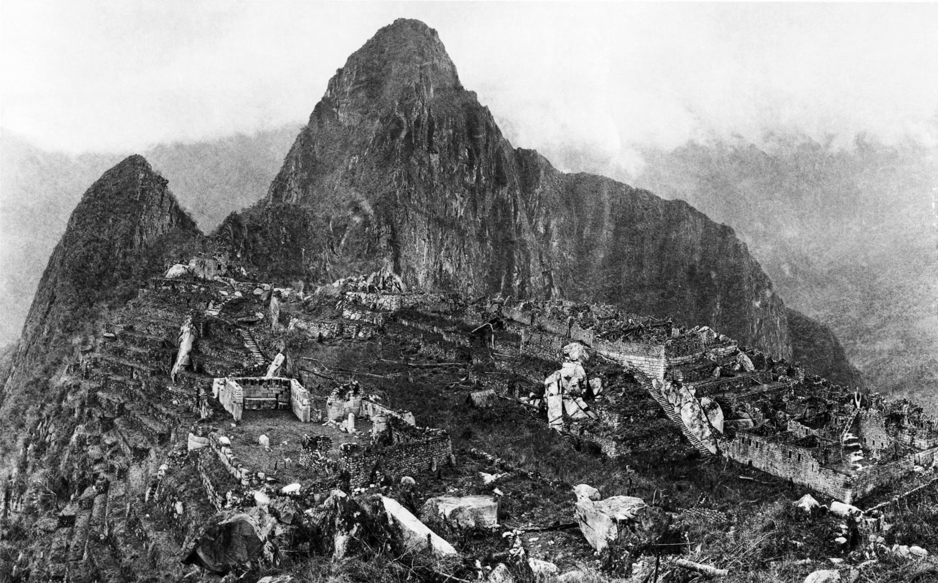 |
| Machu Picchu - 1912 - Wikimedia Commons |
 |
| Machu Picchu - 2018 |
Q: You mentioned a rainbow mountain, can you tell me more about that?
A: The rainbow mountains were far away from Cusco. We had to get up at 4 in the morning to go there. We took a van part of the way to the mountain and then had to hike for about an hour to the mountain. We did not go all the way to the top of the mountain because it was steep and the altitude was very high. The mountaintop is more than 5000 meters above sealevel. It snowed while we were hiking. My dad went to the top and took pictures. The mountain’s real name is Vinicunca, but it is called the rainbow because it has lots of different coloured rocks and sand. The colours come from the minerals in the rock. Yellow is sulfur, red is iron, and green is chlorine. After seeing the mountain we walked back to the van. I accidentally left my sweater where we had lunch, but the tour guide picked it up for us and I got it back after we went to Machu Picchu.
 |
| Vinicunca - The Rainbow Mountain |
 |
| Its cold above 4500 meters! |

Q: What are your plans for the next part of your trip?
A: Right now we are in Lima, tomorrow we fly home, I am really excited to be back at Maple. I miss Maple, but we have to get up at 3 in the morning for our plane. I am grumpy when I wake up early so tomorrow I will probably be grumpy and I will probably get yelled at. But at least we’ll be heading home.
Wednesday, 26 September 2018
The Maple Crew Visits Peru (Part 3)
The Maple crew is currently in Peru, embarking on some land travel while Maple sits out the hurricane season in the Rio Dulce, Guatemala. Here are some more thoughts from Ella (11 year old, Grade 7) about her trip to Peru.
Q: In your last post you wrote about what you’d seen in Arequipa. Your sister shared some details about the Colca Canyon, hiking and seeing Andean Condors. What have you been doing since then?
A: Since then my family and I went to Puno to see Lake Titicaca. The word Titicaca means “stone puma”. Lake Titicaca is at an altitude of 3800 meters. While at Lake Titicaca we went on a cultural exchange which included a trip to the Uros Islands which are floating islands made of reeds, an overnight stay with a local family on Amantani Island, and a brief stop at Taquile Island.
Q: What was the most memorable part of your visit to Lake Titicaca?
A: The most memorable part of Lake Titicaca was seeing the floating reed islands. The reed islands have to be anchored or else they might float into the Bolivian part of Lake Titicaca.

Q: Why do the reed islands exist? Can you tell us a bit more about how the islands are made and what life is like on the islands?
A: The reed islands exist because the Uros people were trying to escape war between tribes in pre-Incan Peru. The islands are made by stacking layers reeds on top of floating root blocks. In the beginning there are five layers of reeds but as time goes on the reeds rot and more layers need to be added to keep the island from sinking. The reed islands can last up to 45 years if they are well cared for. A big island can house up to 10 family’s while a small island can only house 2. The houses on the reed islands are entirely made of reeds. On the island they have to cook out in the open, they use the reeds as their fire source. The clothes on the reed island are very similar to the clothes on Amantani Island. For a bathroom they build separate islands to use as bathrooms. When you go to the bathroom the reeds will soak up your waste.
Q: You stayed overnight with a family on Amantani Island, that must have been an interesting experience. Can you tell me a bit about what that was like?
A: Staying over night in some ones house was an interesting experience. We got a bedroom to ourselves but the bathroom was outside and you had to dump a bucket of water into the toilet to flush it. The kitchen was small and did not have a sink or many counters. The meals at the house were very tasty and filling.


Q: Can you tell me a bit more about the culture of people on Amantani Island?
A: On Amantani Island the people all wear very beautiful outfits. The men wear very colourful ponchos. The women all wear plain green skirts and a very colourful blouse with an elaborate design on it. They also wear a thick belt that overlaps the blouse and the skirt. then they wear a shawl over top of all their other clothes. On Amantani Island they found a way to preserve potatoes for 60 years. The way that they preserve the potatoes is they put them on top of a mountain in the winter. then when the potatoes are frozen they stomp on them until all of the water has been squeezed out of them the potatoes. To eat the dehydrated potatoes all you have to do is rehydrate them. Another interesting fact about Amantani Island is that the husband in the family makes all the clothes for the girls and the wife makes all the clothes for the boys.
 |
| Uros Islands, Lake Titicaca, Peru |
Q: In your last post you wrote about what you’d seen in Arequipa. Your sister shared some details about the Colca Canyon, hiking and seeing Andean Condors. What have you been doing since then?
A: Since then my family and I went to Puno to see Lake Titicaca. The word Titicaca means “stone puma”. Lake Titicaca is at an altitude of 3800 meters. While at Lake Titicaca we went on a cultural exchange which included a trip to the Uros Islands which are floating islands made of reeds, an overnight stay with a local family on Amantani Island, and a brief stop at Taquile Island.
Q: What was the most memorable part of your visit to Lake Titicaca?
A: The most memorable part of Lake Titicaca was seeing the floating reed islands. The reed islands have to be anchored or else they might float into the Bolivian part of Lake Titicaca.
 |
| Reed Island supporting 3 families, Lake Titicaca, Peru |
Q: Why do the reed islands exist? Can you tell us a bit more about how the islands are made and what life is like on the islands?
A: The reed islands exist because the Uros people were trying to escape war between tribes in pre-Incan Peru. The islands are made by stacking layers reeds on top of floating root blocks. In the beginning there are five layers of reeds but as time goes on the reeds rot and more layers need to be added to keep the island from sinking. The reed islands can last up to 45 years if they are well cared for. A big island can house up to 10 family’s while a small island can only house 2. The houses on the reed islands are entirely made of reeds. On the island they have to cook out in the open, they use the reeds as their fire source. The clothes on the reed island are very similar to the clothes on Amantani Island. For a bathroom they build separate islands to use as bathrooms. When you go to the bathroom the reeds will soak up your waste.
Q: You stayed overnight with a family on Amantani Island, that must have been an interesting experience. Can you tell me a bit about what that was like?
A: Staying over night in some ones house was an interesting experience. We got a bedroom to ourselves but the bathroom was outside and you had to dump a bucket of water into the toilet to flush it. The kitchen was small and did not have a sink or many counters. The meals at the house were very tasty and filling.
 |
| Ella grinding quinoa to make flour. |
Q: Can you tell me a bit more about the culture of people on Amantani Island?
A: On Amantani Island the people all wear very beautiful outfits. The men wear very colourful ponchos. The women all wear plain green skirts and a very colourful blouse with an elaborate design on it. They also wear a thick belt that overlaps the blouse and the skirt. then they wear a shawl over top of all their other clothes. On Amantani Island they found a way to preserve potatoes for 60 years. The way that they preserve the potatoes is they put them on top of a mountain in the winter. then when the potatoes are frozen they stomp on them until all of the water has been squeezed out of them the potatoes. To eat the dehydrated potatoes all you have to do is rehydrate them. Another interesting fact about Amantani Island is that the husband in the family makes all the clothes for the girls and the wife makes all the clothes for the boys.
 |
| Dressed in traditional clothing for welcome party. |
 |
| Ella dancing with our host family. |
 |
Subscribe to:
Posts (Atom)